- Neighborhoods
-
Community
-
- Overview History Vision Newsroom News Releases Pilot Newsletter Media Contact Projects Volunteer
- Engage Milwaukie Events City Calendar Recreation Biking in Milwaukie Parks and Trails Directory North Clackamas Parks and Recreation Reserve a Room Library
- Schools North Clackamas School District MHS Student of the Month Public Safety Police Clackamas Fire District #1 Code Compliance Emergency Preparedness Emergency Notifications Garbage & Recycling
-
- Business
- Departments
-
Useful Links
-
- Jobs Alerts & Notifications Email Subscriptions Emergency Notifications Meetings City Services A-Z Mapping & GIS
- Contact the City Staff Directory Request a Public Record Report a Code Violation Report a Pothole Report Misconduct Schedule an Inspection Documents & Forms Documents and Reports Forms, Permits, and Applications
- Helpful Links Digital Archives Library Catalog Municipal Code Purchase a Parking Permit Paperless Billing Pay a Ticket or Utility Bill Urban Forest
-
Concept Plan
The Concept Plan, which includes the design itself as well as other background information about the project, is available for review. Drafts of the earlier concept design itself (the March 18 version and the Feb 11 version) are also available, if you want to see the evolution of the design in response to comments and feedback.
A memo summarizing the Traffic Impact Analysis that was conducted to look at potential effects of the proposed traffic diversions is available.
The concept design evolved from the consultant team's attempt to reflect the public comment received at the first public workshop (Dec 2014). It proposes improvements in specific locations and is a framework for future improvements. The design suggests concept-level improvements, with an awareness that more detailed engineering design will be necessary to determine specific dimensions and locations (with respect to existing driveways, utility poles, etc.).
Drafts of the concept design were repeatedly revised in response to public input. The PAC reviewed and discussed the Feb 11 version of the draft design, and a Summary of PAC Comments, as well as a Summary of PAC Agreements from an additional meeting on March 4, are available for review on the project webpage. Additional input from the second public workshop on March 18, 2015, was also incorporated into revisions to the draft---a summary of public comments and questions from the second workshop is available as a reference.
The Feb 11 version of the draft design includes two types of drawings:
1. Aerial views of various segments of the corridor, with proposed improvements
2. Cross-sections drawings, with typical measurements of the width of the street
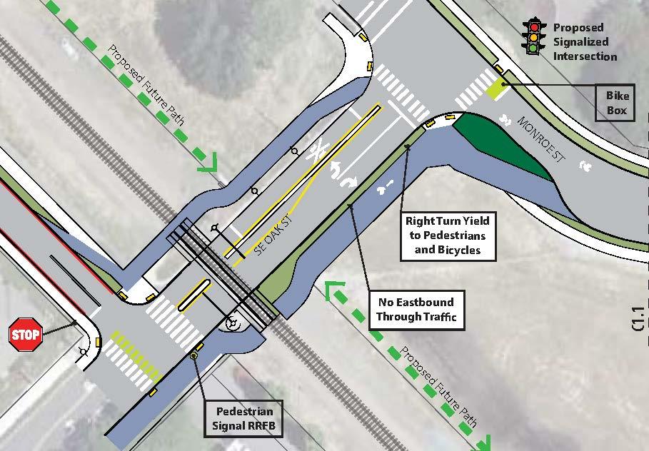
For the section between Campbell St and 37th Ave, note that there are two proposed options--one with bikes sharing the roadway and pedestrians on a sidewalk, the other with bikes and pedestrians on a separated path.
For the section between 42nd Ave and Linwood Ave, note that the March 18 version of the draft erroneously shows a new curb along the south side--the actual proposal is to leave the south side edge of pavement as is, with no curb. This error will be corrected in the next version of the design.
In addition, there is a suggestion of establishing a separated path across the triangular McFarland site between Oak St and 37th Ave, next to the railroad tracks with a crossing onto Washington St instead of Monroe St. With the Washington St alignment, bikes would continue on Washington St up the hill across 40th and 42nd Aves, connecting back to Monroe St via Ada Ln to Home Ave. With this alternative, a partial diverter is proposed at 42nd Ave.
The development of a Concept Plan for the Monroe Street Neighborhood Greenway is an effort based on several basic objectives:
- Make Monroe Street safer by reducing vehicle volumes and speeds.
- Provide separated facilities for pedestrians.
- Bikes and autos share space in the street.
- Make crossings safer for all users.
- Create a unified character along Monroe Street.
- Identify, prioritize, and phase corridor improvements.
Early in the design process, the consultant team developed a Needs and Opportunities Memo to identify existing conditions on Monroe Street, including recommended improvements to make the street an effective neighborhood greenway. The consultant team also prepared an Evaluation Matrix to show how effectively the various elements proposed for different segments of Monroe Street meet key criteria for the project.