- Neighborhoods
-
Community
-
- Overview History Vision Newsroom News Releases Pilot Newsletter Media Contact Projects Volunteer
- Engage Milwaukie Events City Calendar Recreation Biking in Milwaukie Parks and Trails Directory North Clackamas Parks and Recreation Reserve a Room Library
- Schools North Clackamas School District MHS Student of the Month Public Safety Police Clackamas Fire District #1 Code Compliance Emergency Preparedness Emergency Notifications Garbage & Recycling
-
- Business
- Departments
-
Useful Links
-
- Jobs Alerts & Notifications Email Subscriptions Emergency Notifications Meetings City Services A-Z Mapping & GIS
- Contact the City Staff Directory Request a Public Record Report a Code Violation Report a Pothole Report Misconduct Schedule an Inspection Documents & Forms Documents and Reports Forms, Permits, and Applications
- Helpful Links Digital Archives Library Catalog Municipal Code Purchase a Parking Permit Paperless Billing Pay a Ticket or Utility Bill Urban Forest
-
Project Maps
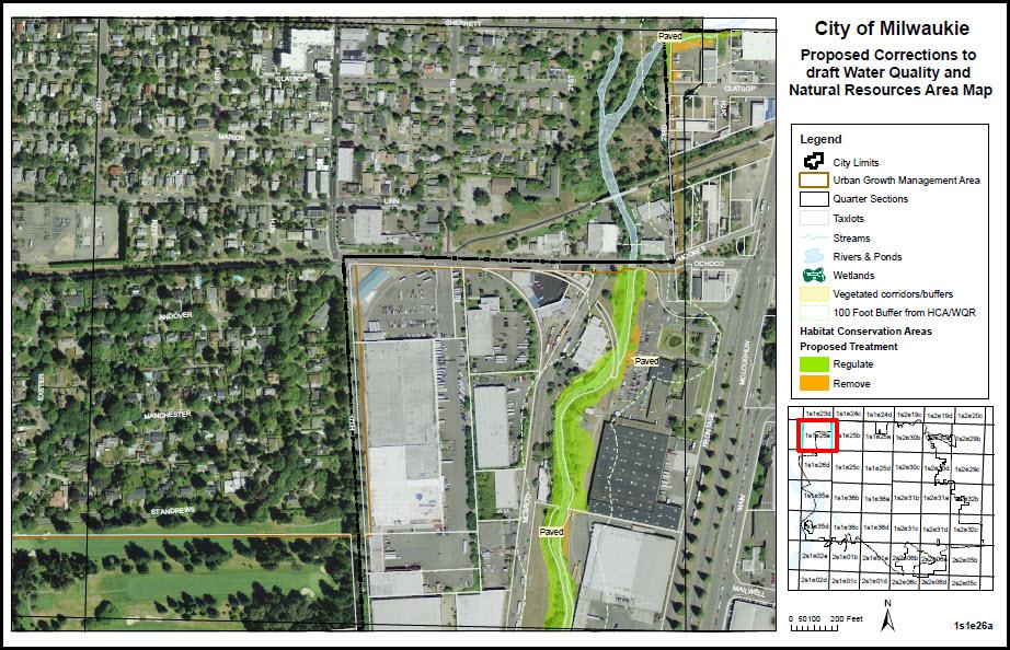
Metro provided an initial map of the Habitat Conservation Areas (HCAs) in Milwaukie that will be subject to the new Title 13 regulations. (Click here to view the initial map.)
Before adopting a final version of the map, the City has corrected obvious errors to make the new map more accurate.
Click here to read a memo explaining Metro’s original mapping process and how the City will approach making changes to the proposed map.
Click here to view the adopted version of the new Natural Resource (NR) Administrative Map, which includes newly designated HCAs as well as existing Water Quality Resources (WQRs) within the city limits. A more detailed version of the adopted NR Administrative map is available in mapbook format here.
The new code provides a process for individual property owners to propose changes to the new map, to be evaluated on a case-by-case basis.